_____________________________________________________
The area I tried renovating is located on 188 N State in Chicago, IL. This street is mainly used for the Red Line, transferring from line to line, attractions for tourists & citizens, and jobs. This popular place is full of opportunity and I believe it could use more restaurants and more civilian-friendly things, such as seats and mobile charging stations. That's essentially what I tried to tackle as an architect of this space. I tried to make this space more citizen-friendly.
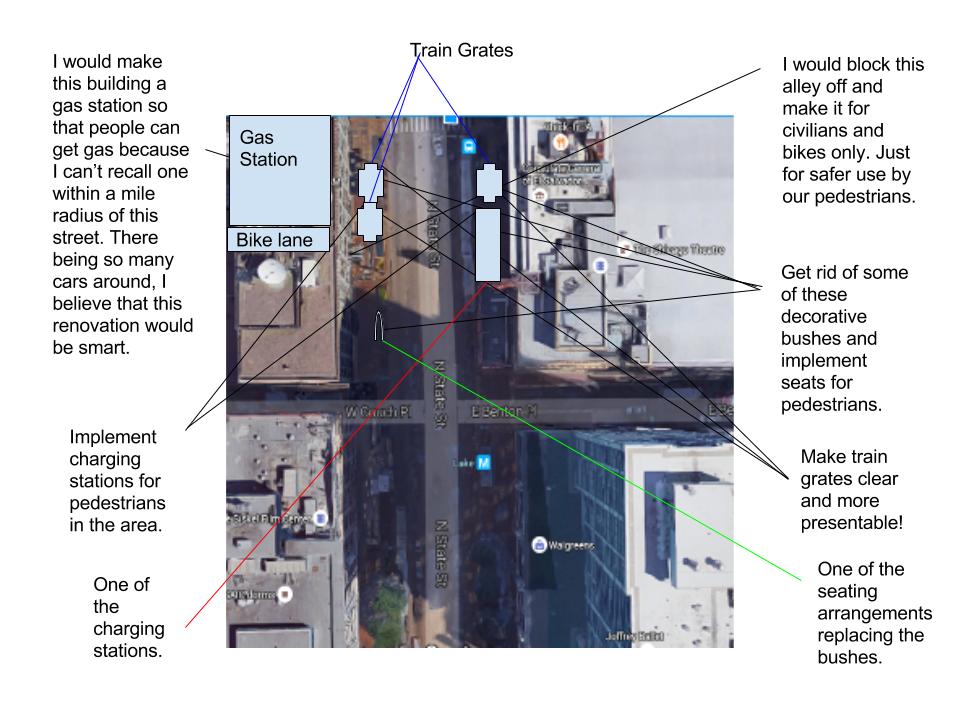
The space I chose is shaped like a rectangular. The length of this rectangle is 374ft and the width is 110ft. The area of a rectangle is length X width. 374 X 110 = 41140ft (squared). Below I will show a diagram of this space and I've labeled a few things I found wrong with it.

DNR "Issues with Lake Red Line Area," Web. 24 May, 2016.
DNR "Resolved Issues with Lake Red Line Area," Web. 24 May, 2016.
My designs were inspired by one area. I was definitely inspired by the idea of mobile charging stations, which I learned about from the AT&T mobile charging stations in New York City. My other inspiration is also from New York, where Metropolitan Transportation Authority created better looking and much safer train grates for New Yorkers with high heels and others.
Below is my 3D model of the improvements I chose to make. In my model you will see a number of different structures and shapes. The light grey boxes are representative of the 3 buildings and the one wedge shaped building is my new gas station design, with the small rectangle shaped structures in front being gas tanks. The two small white shapes represent the new and improved clear train grates. The three small yellow pyramids represent some of the seating arrangements. The one cylinder represents one of the mobile charging stations.
The volume of the seats (pyramids) in my 3D model is: height: 11mm X length: 11mm X width: 20mm/3 = 806.67mm (cubed). The volume of my charging station (cylinder) in my 3D model is: height: 11mm X radius: 10mm (squared) X pi = 3455.75mm (cubed).
There’s a concept called “T.H.I.S” that I will briefly address. T stands for transportation, and my improvements relate to transportation because of the renovation of the Lake Redline area and my idea of blocking off the alley for safer bike commutes. H stands for housing, and my improvements relate to housing because the Lake redline is transportation to an assortment of different homes for Chicago civilians and even hotels for visitors. I stands for infrastructure, and my improvements relate to infrastructure because I plan on implementing charging stations which requires an alternating current system to carry power far distances. S stands for services, and my improvements relate to services because the charging stations will require an electricity company to make it happen.
First I thought about the traffic that would generate from there being a gas station and no alleys, but then I thought that maybe I could only make one alley for bikes only. I learned after a while that this street isn’t as perfect as I once thought. Next time, I would definitely look into making the charging stations cost money, just to make more money.
No comments:
Post a Comment